前言
在离线环境中使用地图功能,需要提前下载地图瓦片到本地。本文详细介绍如何使用 QGIS 添加高德地图源并下载指定区域的离线瓦片。
一、下载安装 QGIS
1.1 下载 QGIS
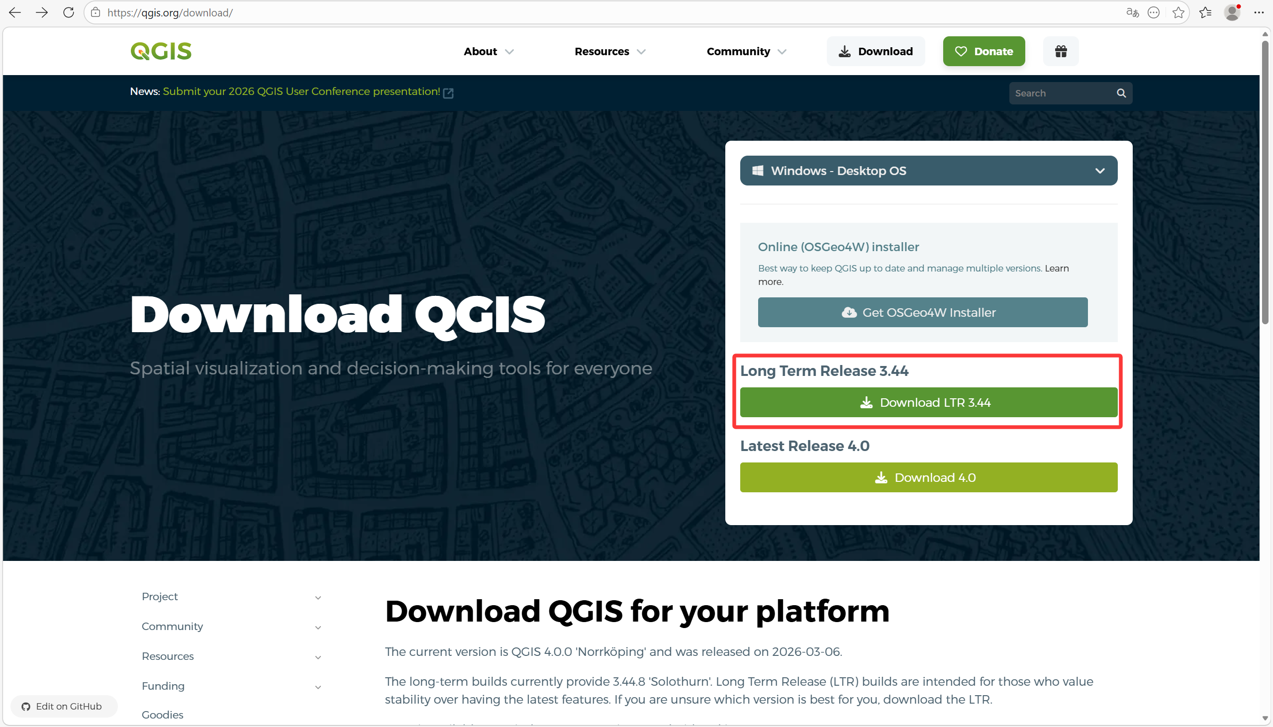
官网地址:https://qgis.org/zh-Hans/site/forusers/download.html
推荐下载:QGIS Standalone Installer(长期支持版)
- Windows 64位:
QGIS-OSGeo4W-3.34.x-Setup-x86_64.exe - 文件大小:约 500 MB
![网站下载页面]()
1.2 安装步骤
- 双击下载的安装文件
- 选择安装路径(建议默认)
- 勾选
Create Desktop Icon(创建桌面图标) - 点击
Install等待安装完成 - 安装完成后,桌面出现 QGIS 图标
1.3 启动 QGIS
双击桌面 QGIS 图标启动软件

二、安装 QTiles 插件
2.1 打开插件管理器
菜单栏:Plugins → Manage and Install Plugins
2.2 搜索并安装
- 在搜索框输入:
QTiles - 找到
QTiles插件 - 点击
Install Plugin安装 - 安装完成后关闭窗口
2.3 验证安装成功
菜单栏:Plugins → 应该能看到 QTiles 选项
三、添加高德地图源
3.1 打开 XYZ Tiles 管理
左侧 Browser 面板 → 找到 XYZ Tiles → 右键点击 → New Connection
3.2 填写连接信息
高德街道地图(推荐)
| 参数 | 值 |
|---|---|
| 名称 | 高德街道 |
| URL | https://webrd01.is.autonavi.com/appmaptile?lang=zh_cn&size=1&scale=1&style=8&x={x}&y={y}&z={z} |
| Min. Zoom Level | 1 |
| Max. Zoom Level | 15 |
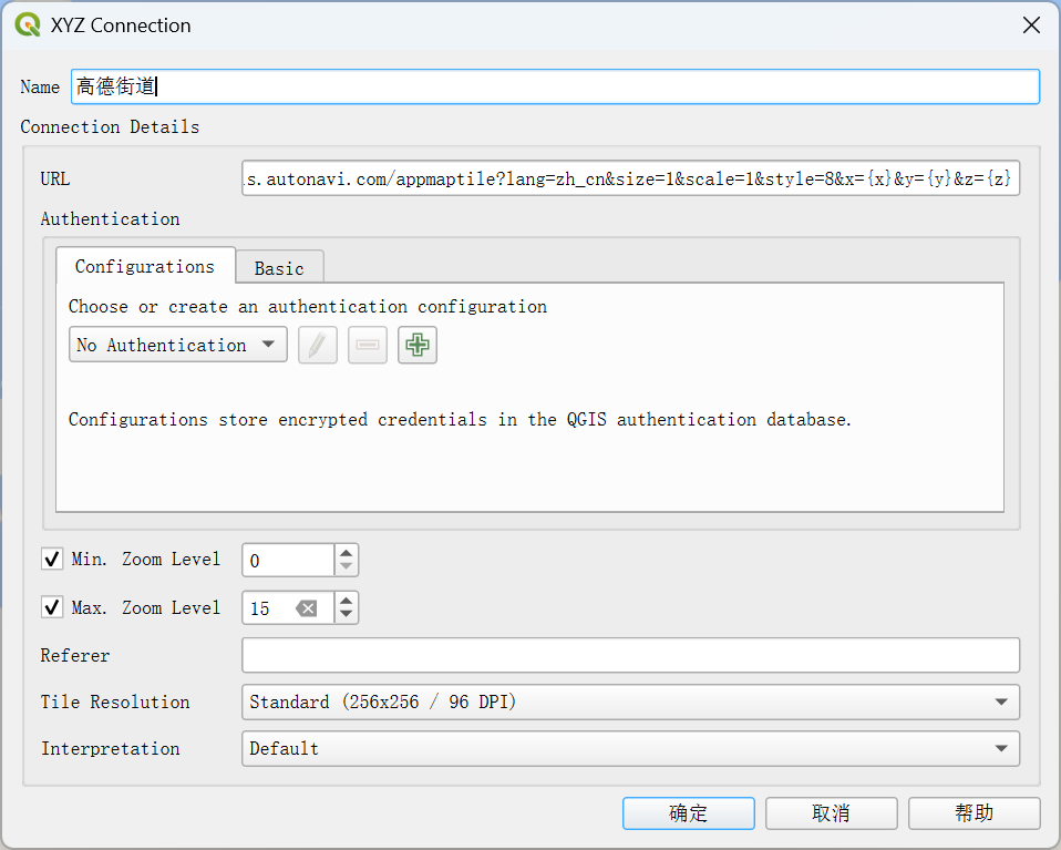
ℹ️ 提示
OpenStreetMap的Max. Zoom Level最多只能选择到14
高德卫星地图(可选)
| 参数 | 值 |
|---|---|
| 名称 | 高德卫星 |
| URL | https://webst01.is.autonavi.com/appmaptile?style=6&x={x}&y={y}&z={z} |
| Min. Zoom Level | 1 |
| Max. Zoom Level | 18 |
高德卫星+街道标注(可选)
| 参数 | 值 |
|---|---|
| 名称 | 高德卫星标注 |
| URL | https://webst01.is.autonavi.com/appmaptile?style=8&x={x}&y={y}&z={z} |
| Min. Zoom Level | 1 |
| Max. Zoom Level | 18 |
3.3 保存连接
填写完成后点击 OK 保存
四、加载高德地图
4.1 加载地图图层
左侧 Browser 面板 → 展开 XYZ Tiles → 双击 高德街道
4.2 地图显示
地图会在主窗口中显示,使用鼠标拖动和滚轮缩放浏览
五、定位到目标区域
方法一:手动定位
- 用鼠标拖动地图到目标区域
- 滚轮放大,逐步定位到具体位置
方法二:坐标定位
- 菜单栏:
View→Geolocation→Zoom to Coordinates - 输入目标坐标(如扬州市:纬度 32.39,经度 119.42)
- 点击
Zoom
六、下载地图瓦片
6.1 打开 QTiles 插件
菜单栏:Plugins → QTiles → QTiles
6.2 设置下载参数
Tileset name: 扬州(自定义名称)

Output:
  Format: Directory          # 输出为目录结构
  Path: D:\yangzhou_tiles    # 输出路径

Extent:                      # 下载范围
  点击右侧按钮 → "Draw on Map" → 在地图上框选区域
  或直接输入坐标:119.022934, 119.912792, 32.223636, 33.422056 [EPSG:4326]

Zoom:                        # 缩放级别
  Minimum zoom: 0
  Maximum zoom: 15

Tile Parameters:
  Tile size: 256 px
  Tile format: PNG
  DPI: 96
  Quality: 70%
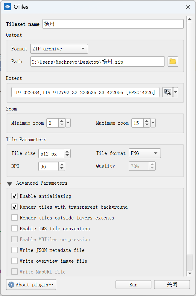
6.3 开始下载
点击 Run 按钮开始下载
6.4 等待完成
进度条显示:Rendering: X from Y (Z%)
下载完成后自动关闭窗口
七、下载结果
7.1 目录结构
D:\yangzhou_tiles\
└── 扬州\
    ├── 0\
    │   └── 0\
    │       └── 0.png
    ├── 1\
    │   └── ...
    ├── ...
    └── 15\
        └── ...
7.2 存储空间参考
| 级别范围 | 瓦片数量 | 存储空间 | 适用场景 |
|---|---|---|---|
| 0-12 | 约 500 张 | 约 5 MB | 省级概览 |
| 0-14 | 约 3,000 张 | 约 200 MB | 市级概览 |
| 0-15 | 约 12,000 张 | 约 1 GB | 街道级别 |
| 0-16 | 约 50,000 张 | 约 4 GB | 详细级别 |
八、Java 后端代码
8.1 Controller 代码
package com.mcxx.controller;

import org.springframework.stereotype.Controller;
import org.springframework.web.bind.annotation.PathVariable;
import org.springframework.web.bind.annotation.RequestMapping;
import org.springframework.web.bind.annotation.RequestMethod;
import org.springframework.web.bind.annotation.ResponseBody;

import javax.servlet.http.HttpServletResponse;
import java.io.*;

@Controller
@RequestMapping("/map")
public class MapController {


    // 瓦片存储根目录(根据实际情况修改)
    private static final String TILE_ROOT_PATH = "/data/map/tiles";
    private static final String BLANK_TILE_PATH = TILE_ROOT_PATH + "/blank.png";

    /** * 获取地图瓦片 * URL格式: /map/tile/{z}/{x}/{y} */
    @RequestMapping(value = "/tile/{z}/{x}/{y}", method = RequestMethod.GET)
    @ResponseBody
    public void getTile(
            @PathVariable("z") int z,
            @PathVariable("x") int x,
            @PathVariable("y") int y,
            HttpServletResponse response) {


        String tilePath = TILE_ROOT_PATH + "/" + z + "/" + x + "/" + y + ".png";
        File tileFile = new File(tilePath);

        response.setContentType("image/png");
        response.setHeader("Cache-Control", "max-age=31536000");

        if (!tileFile.exists()) {

            File blankTile = new File(BLANK_TILE_PATH);
            if (blankTile.exists()) {

                outputFile(blankTile, response);
            } else {

                response.setStatus(HttpServletResponse.SC_NOT_FOUND);
            }
            return;
        }

        outputFile(tileFile, response);
    }

    /** * 地图定位页面 */
    @RequestMapping(value = "/location", method = RequestMethod.GET)
    public String locationPage() {

        return "map/location";
    }

    private void outputFile(File file, HttpServletResponse response) {

        try (FileInputStream fis = new FileInputStream(file);
             OutputStream os = response.getOutputStream()) {

            byte[] buffer = new byte[4096];
            int bytesRead;
            while ((bytesRead = fis.read(buffer)) != -1) {

                os.write(buffer, 0, bytesRead);
            }
            os.flush();
        } catch (IOException e) {

            e.printStackTrace();
        }
    }
}
九、常见问题
问题1:插件列表中找不到 QTiles
解决方法:
Plugins→Manage and Install Plugins→Settings- 勾选
Show also experimental plugins - 重新搜索 QTiles
问题2:地图加载很慢
解决方法:
- 高德地图源在国内访问速度较快
- 如仍慢,可更换高德服务器:
webrd01→webrd02/webrd03/webrd04
问题3:下载时提示 OSM 限制
解决方法:
- 使用高德地图源代替 OSM,可避免限制
问题4:下载中断
解决方法:
- QTiles 支持断点续传
- 重新运行,会跳过已下载的瓦片
- 或减少下载范围/级别
十、资源下载
| 资源 | 下载地址 |
|---|---|
| QGIS | https://qgis.org/zh-Hans/site/forusers/download.html |
| Leaflet | https://leafletjs.com/download.html |
| jQuery | https://jquery.com/download/ |
总结
本文介绍了使用 QGIS + 高德地图源下载离线瓦片的完整流程:
- 安装 QGIS 和 QTiles 插件
- 添加高德地图 XYZ 瓦片源
- 框选下载区域,设置缩放级别
- 下载瓦片到本地目录
- 使用 Java 后端提供瓦片服务
该方案适用于离线环境等场景,可满足基本的地图定位需求。
参考链接:
- QGIS 官网:https://qgis.org/
- 高德开放平台:https://lbs.amap.com/
- Leaflet 官网:https://leafletjs.com/
原文链接:https://blog.csdn.net/weixin_43688610/article/details/158918096